
Groundwater Lowering
The “Groundwater Lowering” program can be used to analyze groundwater lowering with multi-well installations. The calculation can be performed for the lowering of groundwater in several adjacent excavation pits of different depths with any number of wells and in a staggered arrangement. Open dewatering can also be analyzed.
Only available in FRILO Geotechnic Ultimate
Core capabilities
Structural System
- Any number of excavation pits can be defined with different shapes and depths
- Optional waterproof enclosure and waterproof invert
- Selection of various well systems: vertical or horizontal wells, vacuum or gravity wells, open dewatering
- Any number of wells with different diameters, depths and lowering aims
- A staggered arrangement of the wells is possible
- Optional automatic arrangement of wells with predefined diameters, depths and distances from the edge of the excavation pit (optimisation of the well location and depth)
- For the accurate modeling of the excavation pit dimensions, it is possible to import DXF graphics as a background
Soil
- Horizontal soil stratification with different permeabilities
Groundwater
- Free, semi-confined or confined groundwater, optionally with a fixed water level from a nearby water body
- Lowering depth either predefined or adapted to the excavation depth
Verifications
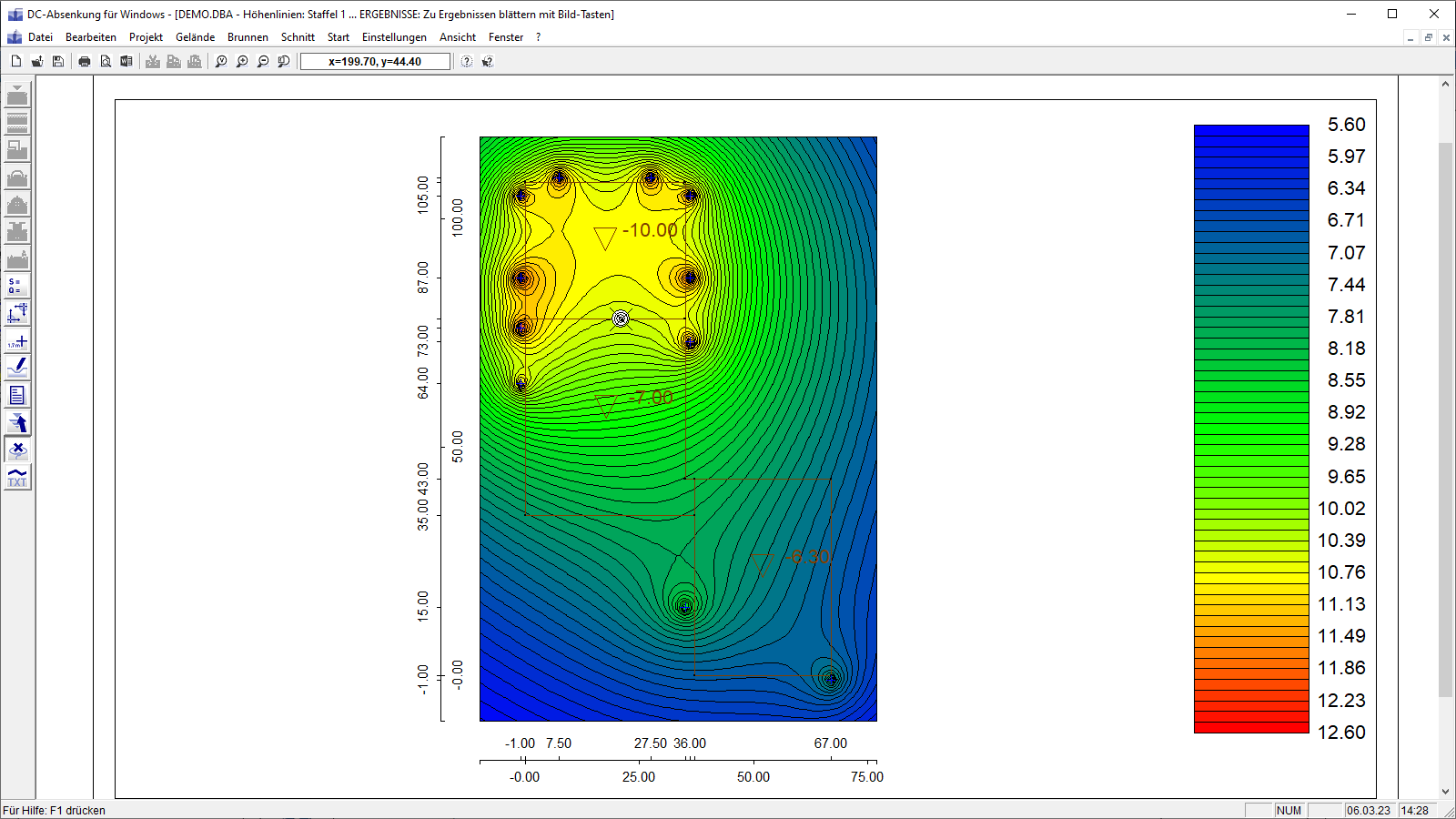
- Calculation and indication of the required pump water quantity, capacity, lowering and wetted filter height per well
- Analysis of the decisive point for the lowering
- Analysis of the required number of wells
- Analysis of the extent according to Sichardt, according to Weyrauch, according to Weber or time-dependent
- Consideration of the influence of the wells on each other depending on their spacing
- Analysis of the residual flows from the wall and the invert as well as the inflows from precipitation for the trough construction
Output profile
- Representation of the lowering via contour lines or coloured areas
- Representation of the water level along any section line
- The lowering can be displayed at any point in the user interface
File formats
- Printer
Export options
- RTF export to MS Word
- graphic export in JPG format
- DXF export
Support resources
News

Corporate headquarters as reinforced concrete skeleton structure
With the construction of a new corporate headquarters, Heidelberg Materials has demonstrated the remarkable range of reinforced concrete as an attractive building material. FRILO and Allplan were used by the structural engineers.
FRILO launches version 2024-2 with powerful updates for structural analysis and design
Highlights include the optimised design of Schöck Isokörbe®, the advanced integration of DC foundation engineering programs into the FRILO environment and new RSX interfaces for detail verifications in steel construction.